


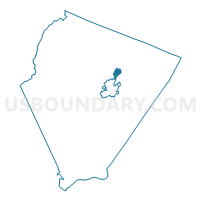
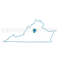
Woodbrook Voting District, Albemarle County, Virginia
About
Outline

Summary
| Unique Area Identifier | 680996 |
| Name | Woodbrook Voting District |
| County | Albemarle County |
| State | Virginia |
| Area (square miles) | 2.06 |
| Land Area (square miles) | 2.00 |
| Water Area (square miles) | 0.06 |
| % of Land Area | 97.24 |
| % of Water Area | 2.76 |
| Latitude of the Internal Point | 38.08401500 |
| Longtitude of the Internal Point | -78.46163090 |
Maps

Graphs
Select a template below for downloading or customizing gragh for Woodbrook Voting District, Albemarle County, Virginia


Neighbors
Neighoring Voting District (by Name) Neighboring Voting District on the Map
- Agnor-Hurt Voting District, Albemarle County, VA
- Branchlands Voting District, Albemarle County, VA
- Dunlora Voting District, Albemarle County, VA
- Hollymead Voting District, Albemarle County, VA
- Northside Voting District, Albemarle County, VA
- Stony Point Voting District, Albemarle County, VA
- Walker Voting District, Charlottesville city, VA
Top 10 Neighboring County Subdivision (by Population) Neighboring County Subdivision on the Map
- Charlottesville city, Charlottesville city, VA (43,475)
- Rivanna district, Albemarle County, VA (17,425)
- Rio district, Albemarle County, VA (15,682)
Top 10 Neighboring Place (by Population) Neighboring Place on the Map
Top 10 Neighboring Unified School District (by Population) Neighboring Unified School District on the Map
Top 10 Neighboring State Legislative District Lower Chamber (by Population) Neighboring State Legislative District Lower Chamber on the Map
Top 10 Neighboring State Legislative District Upper Chamber (by Population) Neighboring State Legislative District Upper Chamber on the Map
Top 10 Neighboring 111th Congressional District (by Population) Neighboring 111th Congressional District on the Map
Top 10 Neighboring Census Tract (by Population) Neighboring Census Tract on the Map
- Census Tract 103, Albemarle County, VA (8,098)
- Census Tract 107, Albemarle County, VA (6,145)
- Census Tract 106.01, Albemarle County, VA (5,817)
- Census Tract 108, Albemarle County, VA (5,325)
- Census Tract 104.01, Albemarle County, VA (4,331)
- Census Tract 8, Charlottesville city, VA (3,642)
- Census Tract 106.02, Albemarle County, VA (2,697)